Tuesday, June 25, 2013

Likya Yolu: Part 2

Day 2: Kirme - Gey (~28 km)

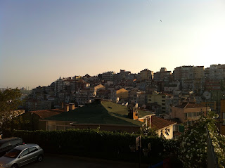
The blaring morning call to prayer called my mind back into consciousness and I was happy to be relieved of my headache from the prior day. I was eager to get out on the trail and see how far I could walk in a day since it was my first full day on the trail. This was my first time hiking a full day at my own pace. You already know the answer to this now. 28 km isn't bad for the 8 hrs or so I spent on the trail given the terrain and elevation gain and loss.

When I reached Faralya I stopped for a huge Turkish breakfast. A standard breakfast includes sliced tomatoes and cucumbers, cheese, olives, jam, honey, lots of bread, and chai tea. Generally, at every meal I ate, an entire fluffy roll of bread was sliced up and given alongside the meal. These were absolutely delicious and I made it my duty to leave no slice left behind at any meal. Okay, enough about food. What about the hiking? No, I haven't even written about dinner yet! Lunch was just nuts and bread, nothing thrilling there. Maybe I should fill in the bit of walking before dinner.

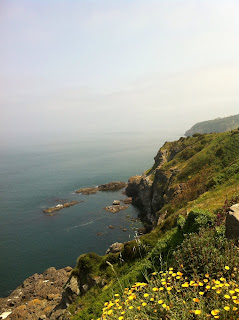
The next land mark on the trail was a beach and seeing as how my current elevation was 500 m, I had a sizable descent ahead of me Likya Yolu style which means losing or gaining elevation very rapidly. I found that the trail often abandoned traditional features like switchbacks opting for a more direct approach. To make matters more interesting there had been a lot construction in area destroying some of the waymarks. This resulted in me seeing what appeared to be the trail way down a very steep slope with no apparent path to reach it and then sliding down the slope through shrubbery hoping it was the correct trail (it was).
Kabak Beach
After about two seconds of ooh-awing at the beach I began a long ascent up some mountain dumping out onto a road where I walked the remainder of the way to the small village of Gey. I was planning on camping near the village on the grassy terraces at the edge of some cliffs to watch the ships sail by while the sun set. Sounds awesome, right? Instead, the mayor's wife invited me to sleep on their balcony where they had some blankets and pillows laid out. Additionally, they offered to make me dinner (for a fee of course). She came out with a huge platter of food. I had and still have no clue what half of the food actually was but all of it was scrumptious. They also gave me a huge bowl of freshly made honey. I didn't want it to go to waste so I stowed what was left over of it in an empty water bottle for future snacks.
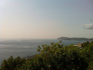
One of my favorite pictures from the trip


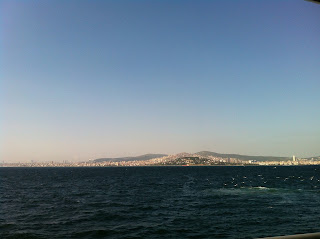
The trail is this picture. Can you see it? I can't.

The sun sets around 8/8:30 pm and after a long day of walking this is a reasonable bedtime for me. After getting situated I watch the sun sink out of view and attempted to drift off to sleep. To my displeasure the only street light in probably a 20 km radius was about 10 meters away from me. I was able to prop up my backpack in such a way to block most of the light. Little did I know was that the mayor's house was the life of the party. There were people talking loudly on the floor below me well into the night. Sleep just didn't really happen that night because I was back on the trail at 6am the following morning. No more taking requests to sleep on open-air balconies. I like my tent and the wilderness.

Day 3: Gey - Letoon (~34 km)

The first half of the day was awesome. The hiking consisted of following treacherous mountain goats trails high above the coast and eventually descending into the delta. The delta of doom and despair for walkers I came to learn. The route was also interspersed with sections of jeep roads connecting very small villages. These villages often didn't have shops to resupply. However, if you head to the mosque, you can usually find clean water.


Typical Lycian Way trail

When I was mission planning and mistakenly trusting the guide book in the morning I was under the impression that I could camp anywhere in the delta seeing as it was flat. My plan was just to walk until I was tired and set up camp for the night somewhere in the delta. The delta doesn't really contain land for camping. There were many kilometers of green houses filling up most of the delta. Furthermore, the road that the waymarks wanted me to follow was flooded since marshland surrounded the land with greenhouses. I proceeded to walk on dusty concrete roads for the next 14 km in the blazing hot sun. I felt like I was walking in the desert walking endlessly towards some mirage in the distance. My mirage being a lovely campsite. Some nice man stopped me and gave me some of his tomatoes from his greenhouse. I was very gracious for the gift but cringed at the though of more weight on my back. After what seemed like an eternity, my eyes rested on a reassuring waymark; the first one I'd seen in hours. I then found a market and restocked on food. It wasn't until 6pm that I found a campsite on the bank of a river. I had walked for 12 hours. I was my feet's worst enemy. Blistered and beat into a pulp, oh feet how I have wronged you. For the rest of the trek my feet exacted their duly revenge on me every step of the way. I learned to ignore the aching pain, well, sort of.

Letoon - Roman ruins 1 km from my campsite. I didn't really care about the ruins at the time because I just wanted to find a campsite

Thursday, June 6, 2013

The Lycian Way (Likya Yolu): Part 1

Before my memory fades I really want to write a few posts on my experiences hiking the Lycian Way, or in Turkish, the Likya Yolu. This post may even be useful for those seeking to embark on the spectacular trek. The Likya Yolu is Turkey's first long distance trek which opened in 1999. It follows the breathtaking Lycian coast in southwestern Turkey beginning in Fethiye and ending in Antalya. The real start and finish are in Ovacik and Hisarçandır respectively. It is said to be 509 km although the GPS waypoints I followed supposed the trail to be 450 km. The trail is a collection of single track paths, mountain goat trails, roads, and sometimes nothing at all connected by periodic waymarks designated by a red stripe underneath a white one. I walked about 350 km of trail in 14 days. If you include detours and getting lost, the total is probably around 375 km. I did not have enough time to walk the entire route so I skipped two sections that seemed boring. Everyday was a new adventure and I hope my trek report inspires some people take on the Lycian Way or at the very least, visit the wonderful country of Turkey (after the ongoing political crisis ends though).

Note: for navigation I used the Gaia GPS app for iPhone and iPad. I saved topological maps (OpenCyleMap) beforehand in addition waypoints provided by Kate Clow and a couple who had hiked the route in 2011. I kept the iPhone on airplane phone which was a terrible mistake. This turns off the GPS functionality. It's much better to just remove the SIM card to save battery and GPS functionality will be retained. I discovered this seven days into the trek. Before that I just used the map and compass to navigate which is a tried and true method but not remotely as easy as GPS.

Pre-Trek

When I left for Istanbul, I had never heard of the Likya Yolu. I didn't even know there were long distance treks in Turkey. What I did know was that there was an adventure waiting to be had in Turkey and I would find myself caught up in it eventually, one way or another.

I arrived in Istanbul on Friday and on Sunday I met Rebecca who told me about how she had hiked part of the Likya Yolu over spring break. Seeing how I happened to have a backpacking backpack, a tent, a thermorest, and a thin sleeping bag, this piqued my interest and I inquired more about the hike to discover there is exactly one guide book by the creator of the trail, Kate Clow. Much to my dismay it was impossible to find this book in Istanbul however I was able to borrow the book long enough to get the entire thing photocopied for a mere 5 lira (~$2.50).

Day 1

With the copied book in hand and after some brief research (read: no clue what I was doing), I set off before dawn on Wednesday morning to the airport. I flew to Dalaman and was able to nab a bus directly to Fethiye (a 1.5 hour trip) for 5 or 10 lira which was pleasant surprise. From Fethiye I hopped on a Dolmuş to get to Ovacik and walked 2 km or so to get to the start of the trail. By this time is was already 1pm.
The start!
 I was eager to start the trek and hoped to get 10-15 km in for the day. Almost immediately after beginning I witnessed some gorgeous views.

Looking down at Ölüdeniz just after starting the trail


 Unfortunately I was a little too conservative on water, developed a splitting headache, got lost, fell onto a thorn bush, and mistakenly walked over a patch of ground swarming with bees (no stings thankfully). By the time I arrived in Kirme ( ~10 km from the start), I pitched my tent, popped some ibuprofen, and passed out well before sundown. Not exactly a good first day.

Evidence of land and rock slides was abundant along the entire trek
The thing is about the trail is: you get lost a lot. Very lost. Every damn day. Twice a day. Maybe three times a day. Okay. Generally, just once a day. That was the general consensus from the people I met on the trail. Many conversations would go something like this:
"How are you?"
"Well, but I got lost today."
"Yeah, me too."
To make matters worse, the guidebook is useless. Reading it is a surefire way to get lost or more lost. The distances are wrong, the descriptions are inaccurate, and it's poorly written. I guess if you needed some kindling for a fire it might be useful. Furthermore, the map included with the book is cartoonish, not-to-scale, and leaves out lots of details. More kindling. Okay, maybe the GPS waypoints are good? Nope. Wrong. The waypoints are many meters off and not very frequent. So how did I manage to do this trek? Besides some luck and frustration, I used the GPS waypoints of the couple who did it in 2011.

Tuesday, May 7, 2013

To Asia and back

One of the unique features of Istanbul is that it spans two continents. I'm staying on European side but on Sunday we ventured into Asian before heading north to the Black Sea. We went with six other exchange students so it was fun to hear about their experiences in Istanbul so far. It was a long and bumpy bus ride there so we didn't do much else that day except for hanging out at a student music festival at Boğaziçi University.

On Monday everyone had to go to class so Danny and I took a ferry to the Princes' islands. There are four or five islands that make up the Princes' islands and we stopped at the largest, Büyükada. We rented some barely working bikes for the day and started off without looking at a map. We just biked up and up and up. Like Istanbul, the island was very hilly. We had a lot fun biking around the island and getting lunch there. On the ferry ride back I could get a better grasp at how expansive the city really is.

Upon returning to land Danny and I began searching for a guide book called Lycian Way. After talking to one of the exchange students who had hiked a segment of the lycian way, I decided to give it a go. It's a 510 km coastal hike in southwestern Turkey from Fathiye to Antalya. The trail was finished in 1999 and is Turkey's first long distance trek. Only downside is that there is only one guide book and it was impossible to find in Istanbul. I only discovered this after I purchased my plane ticket. However I met somebody who is borrowing the book and has agreed to let me photocopy it. Hopefully this works out because I fly tomorrow morning! I'm thinking about flying directly to Cyprus from there but I haven't decided yet. Somehow the prices dont increase drastically even if you are buying two days in advance. As for the trek, I'm hoping to do about 200km of it.
The photo uploader for blogspot with an iPad stinks so I can't put captions or increase the size. Maybe if I get my hands on a computer I can fix it.


Saturday, May 4, 2013

Sleep is for the weak

After working on finals up until the deadline and packing like a maniac with no time to sleep, suddenly I'm on a plane heading to Istanbul with really no clue what I'm doing. The airline, KLM, had a language game and that comprised my training in Turkish. Now I know like two Turkish words. To make matters more interesting I arrived in Istanbul with much less than I departed with. I decided to check my backpack and precisely zero of the bags from the flight from Amsterdam to Istanbul made it successfully due to a mixup at the Amsterdam airport.

So with nothing but an iPad, an empty water bottle, and a passport, my adventure began with the first goal to get to Taksim. The only instruction I received from Abeer ( my friend studying abroad whom I'm staying with ) was to get to Taksim to meet Danny, another friend visiting Istanbul.  It ended up being quite trivial to hop on a bus to Taksim and it was a great way to see some of the city.

Istanbul is incredibly hilly and everyone drives extremely aggressively. If you want to cross the street, waiting will accomplish nothing. You just have to go for it. I also quickly noticed that the city is very homogenous. Diversity is minimal and everyone looks similar, or rather, Turkish.

After meeting up with Danny and taking another bus to meet up with Abeer at his flat, we wasted no time before going out to dinner and deciding on going clubbing that night. Let me quickly summarize my first experience with real Turkish food: delicious. We then ventured back to Taksim with two girls Abeer sort of knew. The night ended up being alot fun at this club on a roof. I met a lot of people and even ran into a guy Danny and I met on the bus earlier that evening.

Six of us piled into a taxi at around 3:30am. Taxi ride from hell. We raced through city going extremely fast but to nowhere.  The driver wasn't going the right way at all. Pretty sure the driver was trying to scam us but he didn't account for one us being Turkish. We didn't get back to one of the girl's flat until 4:30 or so. At this point the last time I slept in a bed, or really slept at all, was Wednesday night for 3 hours or so. It was now Saturday morning so when I was offered one of the extra beds at the flat, there was no hesitation before accepting. We slept for 4 hours before getting the next day started off with a Turkish breakfast (delicious).

Inside the Aya Sofya

Looking up at the dome


Medusa


We said bye to the girls and met back up with Abeer to visit the Hagia Sofia (real spelling: Aya Sofya) and the Basicila Cistern. I didn't even make it to dinner after the day of walking around. I passed out at 6pm and didn't really wake up until 3am. A rest well deserved on my sleeping mat which had finally arrived with my backpack from the airport. Pictures below.